In 2004 a friend of mine who lived part of the year in Hawaii and part of the year in Park City turned me onto the magic of the buoy and a correlation between weather in Hawaii and in the Intermountain West and the beginnings of the Powderbuoy was formed. The basic gist of the Powderbuoy is that weather around the planet is connected and storms that form or stream across the Pacific in the winter happen to cruise above Hawaii and bringing low pressure systems and weather that will eventually hit the Mainland.
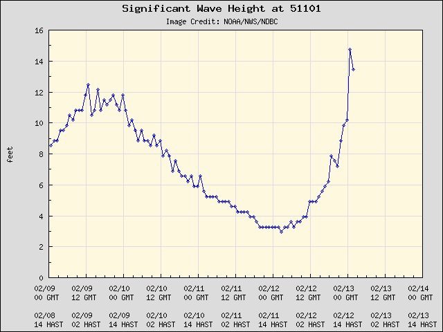
NOAA has numerous buoys that are managed by the National Buoy Data Center and they are out in the oceans sending off data for all sorts of things 24/7. One of the main datapoints that I look for is a big increase in significant wave height (like in the pic above). This means that there is a low pressure and often associated winds and weather that are passing by the Powderbuoy. Based on how far the Powderbuoy is from us, it takes about 2 weeks from when we see a Buoypop until we get that weather in the West.
Is it 100%, no, it’s not, but it works well enough for me and I use it as an early warning signal to keep a storm on my radar screen. If Utah gets socked in with a high pressure system/ridge, which invariably happens at some point every year, the storms have a tendency to swing to the north go up and around Utah and hit Jackson and maybe clip Colorado on the way back down.
Over the years I have noticed correlations with how quickly and how high the buoy pops with severity of storms as well as how long the buoy stays elevated with duration of storms, but again, this is not a perfect science (some say it isn’t science at all, they may be right), but I’ve been planning my skiing around this correlation since 2004.